


Teach English in Mexico City
History
Mexico City (Spanish: Ciudad de México, or Distrito Federal) is the capital city of Mexico. It is the economic, industrial, and cultural center in the country, and the most populous city, with about 8,836,045 inhabitants in 2008. Greater Mexico City (Zona Metropolitana del Valle de México) incorporates 59 adjacent municipalities of the State of Mexico and 29 municipalities of the state of Hidalgo, according to the most recent definition agreed upon by the federal and state governments. Greater Mexico City has a population exceeding 19 million people, making it the second largest metropolitan area in the Americas and the third largest agglomeration in the world. In 2005, it ranked the eighth in terms of GDP (PPP) among urban agglomerations in the world. Mexico City is a major global city in Latin America and ranked 25th among global cities by Foreign Policy’s 2008 Global Cities Index.
According to a study conducted by PricewaterhouseCoopers, Greater Mexico City had a GDP of $315 billion in 2005 atpurchasing power parity, an urban agglomeration with the eighth highest GDP in the world after the greater areas of Tokyo, New York, Los Angeles, Chicago, Paris, London and Osaka/Kobe, and the highest in Latin America. In 2020, it is expected to rank seventh with a $608 billion GDP, displacing Osaka/Kobe. As of 2008, the city had a GDP of about $221 billion, with an income per capita of $25,258, well above the national average and on par with income economies such as South Korea or the Czech Republic.
Mexico City is located in the Valley of Mexico, also called the Valley of Anáhuac, a large valley in the high plateaus at the center of Mexico, at an altitude of 2,240 metres (7,300 ft). The city was originally built as Tenochtitlan by the Aztecs in 1325 on an island of Lake Texcoco. It was almost completely destroyed in the siege of 1521, and was subsequently redesigned and rebuilt in accordance with the Spanish urban standards. In 1524 the municipality of Mexico City was established, known as México Tenustitlán, and as of 1585 it was officially known as ciudad de México.
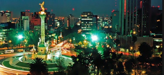
Living in Mexico City
To understand Mexico you have to understand the city that gave the country its name. The former Tenochtitlan, capital of the Aztec empire, is in a basin (incorrectly referred to as a valley) whose human habitation goes back at least 1,400 years. Its founding on the site where the Aztecs found an eagle in combat with a snake is represented in the middle of Mexico’s green, white and red flag. This foundation myth is also represented in many state and local logos of the United States, including the top left-hand corner of the Seal of the City of Los Angeles.
Size matters
Mexico City is full of “firsts” and “mosts”, including the first mint in the Americas, the first university in Latin America, the largest stadium (in seats) in the world, one of the most extensive subway systems, the largest university in the world (UNAM), etc. It was the first city in the world to host the World Cup twice and is said to have the most museums in the world (160+). In the mid-80s it even became the most populated metropolitan area on the planet, a title it now disputes with a few other cities in Asia. With its myriad towns and suburbs spanning three distinct historic periods (pre-Columbian, colonial, modern), Mexico City is a world onto itself.
Mexico City is is the 8th largest metropolitan economy in the world, according to PriceWaterhouse. It had the misfortune of becoming “The Biggest City in the World” at a time when the concept was originally conceived in the 1970s/80s. When humanity took notice of the urban behemoths that were being created by the 20th Century population explosion, these megacities were mushrooming mostly in the Third World. Hence, the tone in which one made reference to places like Mexico City was one of dismay, highlighting the problems of such a concentration of people. Further, this coincided with increasing concern for environmental issues. In terms of international image, the convergence was a fiasco for Mexico City, a place which had been called the “city of palaces” with “the clearest, bluest sky in the world” up until the late 50s, but which became the poster child of urban blight in the 1970s. It was noted as having the most polluted air in the world (now much cleaner).
City of man
The reality is, of course, much more complex. Mexico City has palaces, suburbs, slums, buildings with every known architectural style, clear, spectacular days, and days immersed in haze. It has boulevards lined with skyscrapers and the quaint cobblestone streets of colonial towns that have been enveloped by the urban sprawl. It also has unpaved roads and ramshackle houses. If Mexico is a country of contrasts, Mexico City is appropriately its capital. It has what must be the most contrasting locality in the world, Miguel Hidalgo delegation (which is like a municipality, or a county), where there are slums a couple of miles from where Carlos Slim, the world’s wealthiest man, lives.
There are buildings in the City which are genuinely beautiful and majestic, although often they are flanked by ones that are decrepit and ugly. The best way to experience Mexico City is by covering the eye that can see the ugly surroundings of many of the things you admire, staying alert, wondering at its astonishing history, and enjoying its incredibly temperate climate.
Location, location, location
This seemingly apocalyptic basin, surrounded by hills and volcanoes, can be a very pleasant place to live (if you have the good sense to live near your work). With the increased use of clean fuel, air pollution has declined 70% since 1990 (although traffic has not, as the city is now home to almost 4 million cars and trucks). Further, although now a little more extreme than in the past, the weather is considered very good, with highs in the mid-70s and lows in the 50s pretty much all year round. Although generally applied to its neighbor, Cuernavaca, it is not such a stretch to call it a “city of eternal springtime”. Besides Cuernavaca, with its gardens, Mexico City has easy access to Puebla, a colonial city of nearly 3 million people and other medium-sized cities, such as Toluca and Queretaro.
It is also a mere four hour drive from Acapulco, with its year-round sun-drenched beaches. One can fly directly to any major city in the Americas and Europe with reasonable fares and take advantage of the fact that it is so centrally located, with low flight times to the destinations that interest people most. In sum, Mexico City has everything and it is precisely for that reason that Mexico needs its patch of urban chaos very much.
Getting Around in Mexico City
There are many ways to commute in Mexico City, most notably by car. Due to much work that has been done on Mexico City’s overburdened infrastructure, and the inclusion of new urban highways like the Viaducto, Periferico and Circuito Interior, traffic generally flows. Roads are wide and also mostly one way, thus being more conducive to flowing traffic, even though the maintenance leaves a lot to be desired. This means that when driving you should always beware and expect anything and everything – literally. Driving is much more of an “intuitive” experience in Mexico City. People tend to go in and out of lanes as they please, with the use of turn signals being the exception rather than the rule. Potholes abound, as do pedestrians and sometimes cyclists, and people often don’t respect even the most basic traffic rules. Expect cars to run red lights, to be coming the wrong way on a one-way street, to suddenly stop or turn without warning or logic. Be extra cautious at nights as drunk drivers are to be found, especially on weekends.
Public Transport
When it comes to alternative modes of commuting in the city, Mexico’s capital has very good infrastructure and very cheap public transport. The metro system is extensive, covering virtually the whole city with up to nine different routes. You can find a map of the routes and stations in every metro entrance and you can also buy your tickets there. Having entered the metro with your ticket you can change as many trains and routes as you like without using another ticket. The bus system is also very good, and then there are the “peseros” or mini-buses that are not quite as comfortable as the bus or the metro, but take you anywhere and everywhere.
Public transport is generally quite safe, though you should be wary of traveling late at night. At rush hour public transport can be quite uncomfortable. For ladies traveling by metro, the first two cars of every train have been reserved for them and for young children so that they may travel more comfortably. All public transport is ridiculously cheap.
Going Out Of Town
Traveling out of town is a rewarding experience for Mexico City denizens, considering the wealth of colonial towns, archaeological sites and beaches. Toll roads can be a little expensive, but well worth the security, comfort and speed. The inter-city bus network is also very good, and one can travel very comfortably with first-class bus companies. Air travel is also an option, but because it remains regulated it’s expensive.
The Metro (Subway)
Mexico City has a very efficient subway system which is clean and modern. The fare is inexpensive and transferring from one line to another can be done at no extra cost. The metro is currently undergoing extensive expansion. At this time, there are two airport metro stations.
In Town Bus Service
Bus stops are marked with a big sign with a drawing of a bus. To be sure you have the right bus, state your destination in a quizzical tone and wait for a SI or NO from the driver. Buses cover most of the city. The sign in front of the bus indicates the final destination. Buses are entered from the front and exited through the rear door. You should have small change available for bus fare. Ring the buzzer over the back door prior to your desired stop. Try to move toward the back door a couple of blocks before your destination.
Collectives or Peseros
These are microbuses or V.W. vans that are white with red stripes or gray and green. They have fixed routes and fixed rates depending on the distance traveled. They take as many passengers as the car will hold and drop them anywhere along the route for a fixed price. The driver will hold out his hand, indicating the number of seats available. Peseros can be found on most main avenues.
Trolley Buses
Trolleys run on electricity and are attached to overhead cables. The rate is currently the same as buses and the metro. You can purchase an “abono de transporte,” which is a unique ticket valid for the buses, trolleys and metro.
Taxis
There are different types of taxis available including “Sitio,” “Libres,” Radio and Tourist Taxis, but the taxi recommended (especially at night) is the Radio Taxi. The radio taxis are identifiable by the radio antenna. These taxis are dispatched by radio but will occasionally pick up a fare on the street. Their fare is higher, but they will pick you up at the door and will be waiting at a prearranged time. The radio taxi company always keeps a record of the car and driver that provides the service and for security purposes at night the taxi service is the safest. The telephone directory will list this taxi under “Sitios de Automóviles” or “Taxis.” Never take a street taxi at night.
Climate
Mexico City has a subtropical highland climate (Koppen Cwb), due to its tropical location and high elevation. The lower region of the valley receives less rainfall than the upper regions of the south; the lower boroughs of Iztapalapa, Iztacalco, Venustiano Carranza and the west portion of Gustavo A. Madero are usually drier and warmer than the upper southern boroughs of Tlalpan and Milpa Alta, a mountainous region of pine and oak trees known as the range of Ajusco
The average annual temperature varies from 12 to 16 °C (54 to 61 °F), depending on the altitude of the borough. Lowest temperatures, usually registered during January and February, may reach −2 to −5 °C (28 to 23 °F), usually accompanied by snow showers on the southern regions of Ajusco, and the maximum temperatures of late spring and summer may reach up to 32 °C (90 °F). Overall precipitation is heavily concentrated in the summer months, including dense hail. The central valley of Mexico rarely gets precipitation in the form of snow during winter; the two last recorded instances of such an event were on March 5, 1940 and January 12, 1967. The region of the Valley of Mexico receives anti-cyclonic systems, whose weak winds do not allow for the dispersion, outside the basin, of the air pollutants which are produced by the 50,000 industries and 4 million vehicles operating in or around the metropolitan area. The area receives about 700 millimeters of annual rainfall, which is concentrated from June through September/October with little or no precipitation the remainder of the year. The rainy season runs from June to October when winds bring in tropical moisture from the sea. The dry season runs from November to May, when the air is relatively drier. This dry season subdivides into a cold period from November to February when polar air masses pushing down from the north keep the air fairly dry and a warm period from March to May when tropical winds again dominate but they do not yet carry enough moisture for rain.